Google Maps Timeline is a useful feature that displays your location history, including a detailed record of the places you’ve visited, the routes you’ve taken, and your trips over time. This information is organized on a personalized map, allowing you to see where you’ve been and what you’ve done. The Timeline uses symbols and icons to represent different types of movement, such as walking, cycling, or driving.
It’s important to understand these symbols to use Google Maps Timeline effectively. For example, you can switch between map types and layers to add or remove extra information, such as traffic or biking paths. This allows you to customize the map view to your needs and gain personal insights. Recognizing these symbols as you navigate through your Timeline can help you retrace your steps, discover travel trends, or simply reminisce about past journeys.
Google Maps Timeline Symbols and Meanings
It’s tricky to give you a complete list of Google Maps Timeline symbols, as Google occasionally updates them. However, here are the most common ones you’ll encounter:
Travel Methods:
- Driving: Car icon
- Cycling: Bicycle icon
- Walking: Person walking icon
- Running: Person running icon
- Train: Train icon
- Bus/Tram: Bus icon
- Subway/Metro: Subway icon
- Airplane: Airplane icon
- Boat/Ferry: Boat icon
- Motorcycle: Motorcycle icon

Other Activities:

- Place: Red teardrop-shaped marker (indicates a place you visited)
- Moving: Series of connected dots (shows movement between places, but the specific method is unclear)
- Unknown Activity: Question mark icon (means Google couldn’t determine the mode of transportation)

Things to Note:
- Color Variations: The icons might have slight color variations (e.g., different shades of blue for driving) depending on the specific trip or activity.
- Clusters: If you’ve been to a place many times, the icons might cluster together, making it harder to distinguish individual trips.
- Your Timeline: The best way to understand the symbols on your Timeline is to open it in Google Maps and explore! Tap on specific entries to see more details about the activity and the mode of transportation.
Keeping Up-to-Date:
Google doesn’t provide an official, comprehensive list of Timeline symbols. If you encounter a symbol you don’t recognize, try these:
- Tap on the entry: See if Google Maps provides more context within the entry details.
- Search online: Use keywords like “Google Maps Timeline [symbol description]” to see if others have identified it.
- Check Google Maps help: Occasionally, Google might update its help documentation with information about new symbols.
Understanding Your Movements On Google Maps
Google Maps offers a handy feature called Timeline, letting you keep track of your past travels. Timeline uses small symbols to indicate your mode of transportation for different parts of your journey. Let’s break down what these symbols mean.
Driving
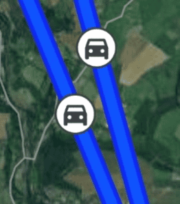
A car icon stands for driving activities. See a car symbol on your Timeline? That means Google Maps believes you were driving a vehicle during that time.

Cycling
If you were pedaling around, you’ll see a bicycle icon marking your cycling trips on the Timeline.
Walking

When you’re covering ground on foot, your Timeline will show a person walking icon to represent those walking segments.
Public Transportation

A train icon in your Timeline indicates you were likely utilizing public transportation options like trains, subways, or buses.

Still (Unknown Transportation)
Sometimes Google Maps isn’t sure what type of transportation you were using. It will then display a question mark symbol. This usually happens for short trips or if your location data was less accurate at that time.
Understanding the Timeline Table
In addition to the symbols, your Google Maps Timeline has a table format for easier viewing. Here’s what you’ll find in the table:
Start Time & End Time
Indicates the beginning and end of a particular travel segment.
Place
The location or establishment you visited.
Transportation Type
Shows the corresponding icon (car, bike, person walking, etc.) for the mode of transportation.
Distance Traveled
The distance covered during that segment of your trip.
Key Takeaways
- Google Maps Timeline provides a visual record of past routes and places visited.
- Timeline symbols indicate different travel modes, enhancing the tool’s usability.
- Recognition of these symbols aids in personal journey insights and map customization.
Understanding Google Maps Timeline
Google Maps Timeline is a feature that provides users with a visual representation of their movements over time. It uses location history collected from their devices to map out routes and places they have visited.
Timeline Basics
Google Maps Timeline is available on the web and through the Google Maps app on Android devices. To access it, you must have Location History enabled. Users can view their past locations and travels in a visual format, with the ability to select specific dates to review their movements for that day. Users can also edit or delete this history at any time to manage their privacy and the accuracy of the data.
Transportation Modes in Timeline
The Timeline feature distinguishes various modes of transportation, such as walking, cycling, and driving. For those who use wheelchairs or skateboards, it can also reflect these movements, differentiating between powered and non-powered transport modes. Transit methods like buses and subways are also tracked, giving users a complete picture of how they’ve traveled from place to place.
Interpreting Colors and Symbols
Colors are a significant part of the Google Maps Timeline, each representing different types of movement. Light blue indicates walking, while cycling and other non-motorized, low-power transport modes are shown in cyan. Dark blue marks driving or traveling by engine-powered vehicles on land or water. Public transportation routes, like those taken by subway or bus, are usually displayed in colors that correspond with the transport line or in a standard red to signify movement. Purple might indicate running, hiking, or special directions provided by Timeline.
Utilizing Timeline for Personal Insights
Google Maps Timeline is a feature in both the Android app and web version of Google Maps. It provides users with a visual representation of places they have visited. This can be a powerful tool for remembering past activities and understanding travel patterns. Let’s explore how to make the most of this feature.
Places and Location History
Google Maps Timeline uses Location History to record places you’ve been to with your mobile devices. It can show:
- Walking routes in light blue
- Cycling or similar transport in cyan
- Driving paths in dark blue
Each color on your Timeline indicates a different mode of transportation, helping you to visualize your movements and identify trends in your travel habits.
Managing Timeline Data
Keeping your Timeline data accurate is important. Here’s how to manage it:
- Open Google Maps Timeline.
- Press on a day or place to edit or remove entries.
- To delete all Location History, choose “Delete all Location History” from settings. Remember, doing so will remove these details permanently.
Managing this data also requires attention to privacy settings. For example, if Web & App Activity is on and you turn off Location History, some location data may still be saved by other Google services.
Practical Applications of Timeline
The Timeline feature has several practical uses:
- Finding locations you’ve visited when you can’t remember the name
- Reviewing travel history for reporting or personal reflection
- Analyzing travel habits to optimize routes or planning future trips
By paying attention to the colors and symbols on the Timeline, you can gain insight into your transportation choices and consider alternative modes such as cycling or walking for future outings.
Frequently Asked Questions
This section addresses common inquiries regarding the interpretation of symbols and accessing the Google Maps Timeline feature.
How can I interpret the icons on my Google Maps timeline?
Every icon on your Google Maps timeline has a different meaning. For instance, a box with a downward arrow lets you switch views on the map. Construction signs indicate road work, and red icons with a minus sign mean a road is closed. To fully understand each symbol, you can refer to the Google Maps Legend through the menu.
What is the significance of the clock symbol on Google Maps?
The clock symbol on Google Maps represents your location history. It shows places you’ve been and the time you spent there. By tapping on this icon, you can view a detailed history of your travel routes and destinations.
How can one tell if there have been modifications to their Google Maps timeline?
Your Google Maps timeline is personal and reflects changes in real-time when you add, edit, or remove locations. If you see modifications that you did not make, you may want to check if someone else has access to your account or if you’ve used a shared device.
What steps are involved in accessing my Google Timeline history?
To access your Google Maps Timeline history, open the Google Maps app, tap your profile picture or initial, and then select ‘Your Timeline’. Here, you can see your travel history, places visited, and routes taken if your location settings were active.
Can you explain the meaning behind the moving symbol in Google Timeline?
The moving symbol in Google Timeline indicates you were traveling. Various symbols show if you were walking, driving, cycling, or using public transport. This helps differentiate the types of movements and modes of travel on your timeline.
How do I view my location history through the Google Timeline app?
To view your location history through the Google Timeline, open the app and tap on ‘Your Timeline’. Your Location History needs to be enabled for this to work. Here, you’ll find a summary of your travels, places you’ve stopped, and the time you’ve spent at each location.