Google Street View is a popular tool for virtual exploration, but there are other options available. This article explores different alternatives to Google Street View, highlighting their unique features, strengths, and weaknesses. Whether you care most about image quality, diverse coverage, ease of use, or contextual information, there’s an alternative out there that’s perfect for you. Let’s go on a virtual road trip to discover the best ways to explore the world from your screen.

Mapping Out Your Options: Alternatives to Google Street View
Google Street View revolutionized how we explore the world from our screens. However, it’s not the only player in the game. Let’s take a virtual road trip and discover some worthy alternatives.
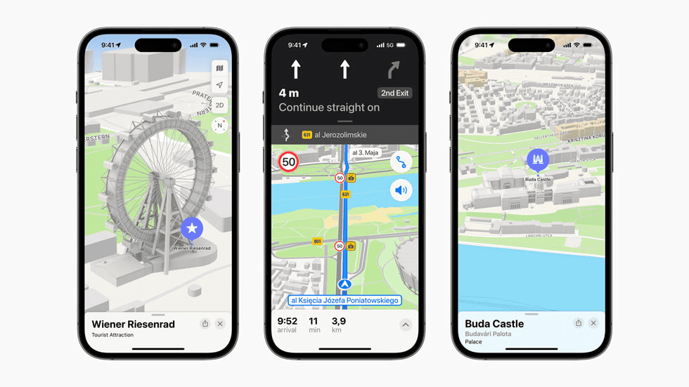
Apple Look Around
Apple’s answer to Street View, Look Around, offers a smooth, intuitive experience. Its high-resolution images and seamless transitions make virtual exploration a breeze. While its coverage isn’t as extensive as Google’s, it excels in detail and clarity, especially in major cities and popular tourist destinations.

Mapillary
If you’re looking for a more community-driven approach, Mapillary is your go-to. This platform uses crowdsourced images to create a comprehensive street-level view of the world. Its coverage is constantly growing, thanks to contributions from users worldwide. Mapillary’s strength lies in its diversity, showcasing off-the-beaten-path locations and hidden gems that you might not find on other platforms.
Bing Maps Streetside
Microsoft’s Bing Maps Streetside might not be the first name that comes to mind, but it’s a solid contender. It offers a decent selection of street-level imagery, although its coverage isn’t as vast as Google’s or Apple’s. However, it makes up for it with its integration with Bing Maps, providing a seamless transition between map view and street-level exploration.
OpenStreetMap
While not strictly a Street View alternative, OpenStreetMap deserves a mention. It’s a collaborative project that creates free and open map data. While it doesn’t offer the same immersive street-level experience, it provides valuable information and context about locations, making it a great companion to other platforms.
Comparing the Alternatives
Let’s take a closer look at how these alternatives stack up against Google Street View:
| Platform | Coverage | Image Quality | Features | Strengths |
|---|---|---|---|---|
| Apple Look Around | Limited, focused on major cities and tourist spots | Excellent, high-resolution with smooth transitions | Integration with Apple Maps, easy navigation | Detail, clarity, user-friendly interface |
| Mapillary | Growing rapidly, thanks to crowdsourced contributions | Varies depending on contributor | Community-driven, diverse coverage | Unique perspectives, off-the-beaten-path locations |
| Bing Maps Streetside | Decent, but not as extensive as Google or Apple | Good, comparable to Google Street View | Integration with Bing Maps, smooth navigation | Ease of use, seamless transition between map and street view |
| OpenStreetMap | Not a street-level platform, but provides valuable map data | N/A | Open-source, collaborative project | Contextual information, complements other platforms |
Choosing the Right Alternative for You
The best Google Street View alternative for you depends on your needs and preferences. If you prioritize image quality and a smooth experience, Apple Look Around might be your best bet. If you’re looking for a more diverse and community-driven platform, Mapillary is a great choice. For a simple and easy-to-use option, Bing Maps Streetside is worth considering. And if you want more contextual information about locations, OpenStreetMap is a valuable resource.
In Conclusion
Google Street View might be the most popular option, but it’s not the only one. There are several excellent alternatives available, each with its own strengths and weaknesses. By exploring these options, you can find the perfect platform to satisfy your virtual wanderlust.
Overview of Google Street View Alternatives
When one thinks about street-level mapping, Google Street View often comes to mind first. It’s a part of the larger suite of Google Maps services, offering panoramic views of many streets worldwide. However, there are several other services that provide similar or complementary capabilities.
Mapillary and KartaView (formerly OpenStreetCam) are two key players in this field. Mapillary is a service that collects and shares street-level photos, allowing users to view and navigate through different locations. It harnesses photos contributed by the community. KartaView, similar to Mapillary, sources its imagery from volunteers and is often used to improve OpenStreetMap data.
Apple Maps, known for its slick interface, provides a feature called ‘Look Around’, which is Apple’s equivalent to Google’s Street View. It offers high-resolution, 3D imagery in several countries, enabling users to explore cities with the ease of a few clicks.
Bing Maps, backed by Microsoft, includes Streetside views—a service analogous to Google Street View—granting users the ability to explore places with panoramic imagery.
Another contender is HERE WeGo, offering detailed maps and navigation assistance across various platforms with a focus on a seamless user experience in transit planning and turn-by-turn navigation.
Yandex.Maps primarily serves Russian users but also provides maps and street views for several other regions. It offers features such as real-time traffic, navigation, and 3D buildings, ensuring comprehensive guidance for users when traveling or exploring new areas.
Below is a brief list of some alternatives to Google Street View:
- Mapillary: Community-contributed street-level photos.
- KartaView: Volunteer-sourced imagery for mapping enhancements.
- Apple Maps Look Around: High-resolution, 3D city tours.
- Bing Maps Streetside: Panoramic place exploration.
- HERE WeGo: Detailed transit and navigation maps.
- Yandex.Maps: Maps and street views with traffic updates.
Evaluating these alternatives, individuals have a variety of choices depending upon their specific navigation and mapping needs, from user-contributed photos to detailed transit maps.
Features and Functionality
When looking at alternatives to Google Street View, different apps and services offer a unique set of features aimed at enhancing the user’s experience with digital maps. These range from immersive views to detailed directions, and from social contributions to offline functionality.
Immersive Mapping Experiences
Users expect to be transported to their desired location virtually through their screens. Alternatives like Mapillary and Kartaview provide comprehensive panoramic imagery that can be a joy to explore. With 3D buildings and 3D views, platforms such as Apple Maps and Bing Maps present realistic depictions of cityscapes, adding depth to the user’s virtual journey.
Navigation and Directions
Efficient routing is crucial for those on the move. HERE WeGo and Apple Maps offer reliable directions and navigation, including voice controls for a hands-free experience. This is especially handy when traveling by public transport or when driving, as both services update with real-time traffic updates, helping users avoid congested routes. For mobile phone users, whether on Android or iOS, having access to precise GPS details and the ability to plan routes around points of interest (POI) turns navigation into a breeze.
User Engagement and Contributions
Community-driven services like OpenStreetMap encourage user engagement by allowing mappers to contribute to the collective mapping effort. These crowdsourced platforms are often open-source, enabling a diverse array of improvements and extensions. Users can typically search for nearby services or locales, read reviews, and even contribute their own findings, ensuring the map remains current and detailed.
Incorporating these features into mapping services empowers users to navigate the world more effectively and enjoyably, whether they are connected to the internet or venturing through areas with limited connectivity and relying on offline use capabilities.
Global Coverage and Accessibility
When exploring the world from the comfort of one’s home, seamless access and widespread reach are crucial. The following describes how various services are broadening their horizons and serving a range of functionalities.
Expanding Geographic Reach
Certain platforms are making impressive strides in their geographic coverage. OpenStreetView, for instance, aims to provide global street-level photography through crowd-sourcing, thus inviting people everywhere to participate. Mapillary, engaging the community, lets users capture street-level images with any camera, contributing to a comprehensive view of diverse locations. They particularly fill geographical gaps that other services may overlook.
- Map Services Offering Wide Coverage:
- Google Earth: Offers extensive satellite imagery and 3D representations, though it is not free.
- HERE WeGo: Known for its route planning and navigation features, available in many countries.
- Yandex Maps and Bing Maps: Both supply mapping services with varying coverage; Yandex is substantial in Russia and Bing globally.
- Maps.Me and Pocket Earth: Offer detailed offline maps, beneficial for areas with limited internet connectivity.
- Waze: Provides real-time traffic information and navigation, increasingly expanding its global presence.
- Apple Maps: Recently has undergone improvements, expanding its detailed maps and street views to more locations worldwide.
Places like Africa and China where some services have limited presence, users benefit from regional apps like Norc, providing tailored services.
Variety of Use Cases
The versatility of modern mapping services extends beyond mere trip planning. For restaurant searches, personal favorites, and locating companies, services like Citymapper and Waze shine with their real-time urban transit and traffic data. They cater to diverse needs from public transportation to travel, ensuring users have the right tools for varying scenarios.
- Utility Across Different Scenarios:
- Hiking and Parks: Platforms like Maps.Me offer terrain details aiding in outdoor exploration.
- Boating and Coastal Navigation: Some apps provide specialized charts for marine navigation.
- Travel and Attraction: Users can discover landmarks and plot itineraries with comprehensive apps easing travel arrangements.
- Public Transportation: Apps like Citymapper depict transit routes and schedules, aiding daily commutes.
The provision of offline maps by several services ensures that users maintain access to navigation and location details without an internet connection. This proves pivotal for individuals exploring remote parks or embarking on international travels where connectivity might be intermittent.
Frequently Asked Questions
Exploring different services for street-level imagery, this section addresses some of the most common queries people have regarding Google Street View alternatives.
What are some popular alternatives to Google Street View?
Multiple services offer panoramic views similar to Google Street View, such as MapQuest and Bing Maps, providing users with ample options to view locations at street level.
Which free apps offer similar features to Google Street View?
Apps like Yandex.Maps and Bing Maps present no-cost alternatives to Google Street View, offering users street-level imagery and various other navigational tools.
Can I access street-level imagery on platforms other than Google?
Yes, street-level imagery is available on platforms like vPike, which uses Google-based maps to give real-time photos and traffic conditions.
Are there any mobile apps that provide street view services like Google Street View?
The discontinuation of Google’s Street View app for Android has led to the emergence of alternative mobile apps, such as MapQuest, offering comparable street view services.
What options are available for street view imagery on iOS devices?
iOS device users have access to alternatives like MapQuest and Bing Maps, which offer their own versions of street-level imagery and navigational features.
How does Bing’s street view feature compare to Google Street View?
Bing’s street view service delivers a user experience akin to Google Street View, with its own unique interface and functionality to browse street-level photographic content.


